
Chota Char Dham
The four Himalayan shrines of Uttarakhand — Yamunotri, Gangotri, Kedarnath, Badrinath
🪔 The yatra
Why pilgrims walk this route
A regional circuit through the Garhwal Himalayas, often confused with the all-India Char Dham. These four shrines mark the sources of the Yamuna and Ganga and the high-altitude abodes of Shiva and Vishnu in the mountains. Completing the route in a single season (May-October) is the lifelong goal of most North Indian Hindu households.
Historical context
The Chota Char Dham gained prominence after the construction of motorable roads in the 1950s-60s opened up routes that previously required 30-45 days of trekking. The 2013 Kedarnath floods reshaped infrastructure massively; helicopter services from Dehradun now make the entire circuit possible in 5-7 days for those willing to skip the trekking ascents.
The route
4-stop yatra · Haridwar / Dehradun → Badrinath, return via Rishikesh
- Stop1
Yamunotri
· Uttarakhand⏱️ 1 daySource of the Yamuna river. The temple sits at 3,293 m below the Bandarpoonch peak. A 6-km trek from Janki Chatti — pilgrims cook rice in the boiling Surya Kund spring as offering.
- •6 km steep ascent from Janki Chatti — palki and pony available
- •Stay overnight at Barkot or Janki Chatti, not at the shrine itself
- Stop2
Gangotri
· Uttarakhand⏱️ 1 daySource of the Ganga (the actual glacial source, Gaumukh, is a 19-km trek from here). The temple is at 3,100 m on the Bhagirathi's banks — Bhagiratha's penance is said to have brought Ganga down here.
- •The temple itself is roadhead — no trek required
- •Gaumukh trek (19 km, permit required) is for serious pilgrims with 3 extra days
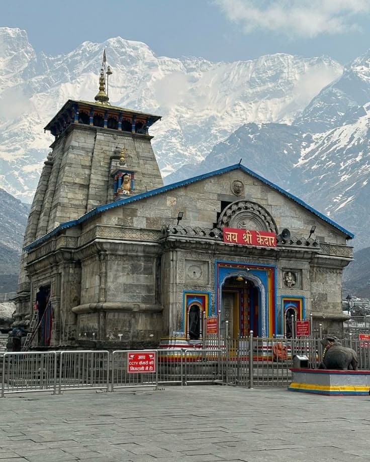
- Stop3
Kedarnath
· Uttarakhand⏱️ 2 daysOne of the 12 Jyotirlinga and the most challenging dhām of the Chota Char Dham. The 18-21 km rebuilt trek from Gaurikund / Sonprayag (or 6-min helicopter from Phata/Sersi) takes you to a 3,583 m shrine that survived the 2013 floods almost intact.
- •Helicopter booking on heliyatra.irctc.co.in opens months in advance — secures sell out within hours
- •Carry rain protection even in June; weather turns within an hour
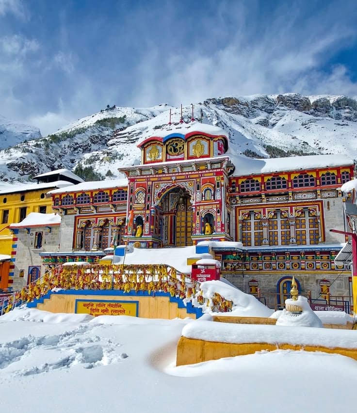
- Stop4
Badrinath
· Uttarakhand⏱️ 2 daysThe highest of the four (3,133 m) and the only one with motorable road access right to the temple. The Tapt Kund hot spring at the entrance is mandatory for ritual ablution before darshan.
- •Combine with Mana Village (4 km, India's last village before Tibet) and Vasudhara Falls

Travel tips
Practical guidance
- 1The traditional clockwise order is Yamunotri → Gangotri → Kedarnath → Badrinath; reversing it saves a day of backtracking
- 2Helicopter packages from Dehradun cover all four in 5 days for ₹70,000-1,20,000 per person — the only way for elderly pilgrims
- 3Pre-register on registrationandtouristcare.uk.gov.in — biometric registration is mandatory at gate checks
- 4Avoid the first 10 days after temple opening (late April-early May) — weather is erratic and crowds peak
Rituals & traditions
What pilgrims observe
- 🪷Cook rice in Surya Kund at Yamunotri as the entry offering
- 🪷Carry Ganga water from Gangotri all the way to Rameswaram if combining with the all-India Char Dham
- 🪷Tapt Kund bath at Badrinath before darshan (water emerges at 55°C)
Prerequisites
Before you start
- ✓Mandatory biometric registration on the Uttarakhand tourism portal
- ✓Medical fitness certificate for Kedarnath if over 60 or with cardiac/pulmonary conditions
- ✓Warm layers even in June — temperatures drop to 4-8°C at the shrines overnight
- ✓AMS (altitude sickness) medication — Diamox if prescribed
Other yatras
More pilgrimage circuits
Begin your yatra
Plan Chota Char Dham day by day
Generate a personalised itinerary in seconds — including transport between stops, suggested stays and a budget estimate. Or open BharatDost (chat icon) for stop-specific questions.